Plan Your Trip
Epic Cape York
Distance
1,432 one way
How
4WD
Where
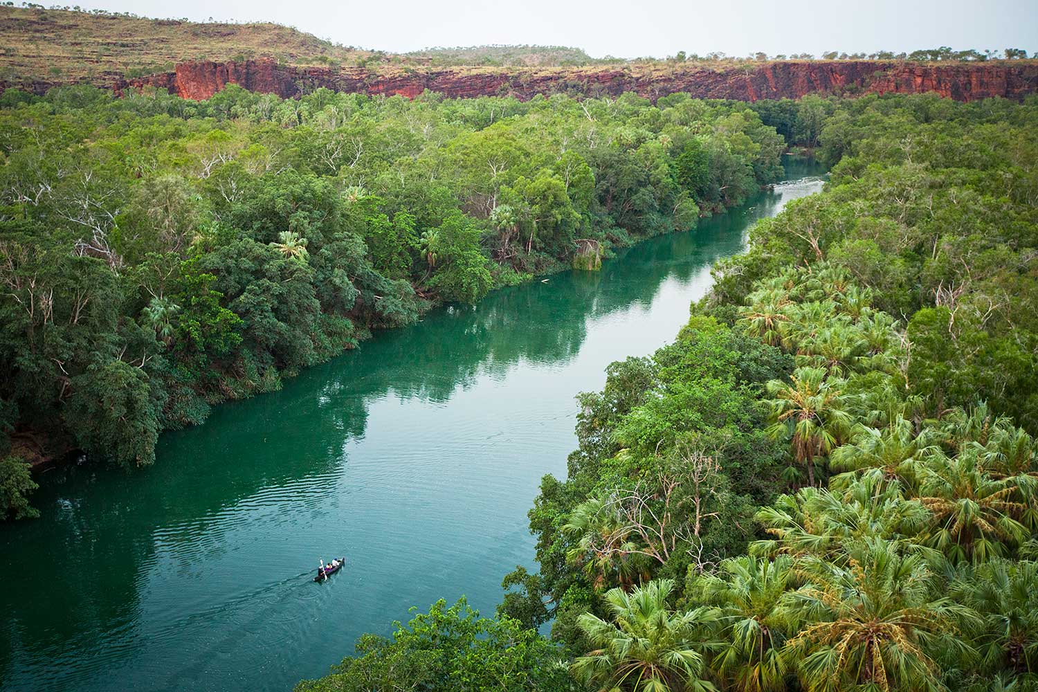
Cairns to Cape York
Date
May to October
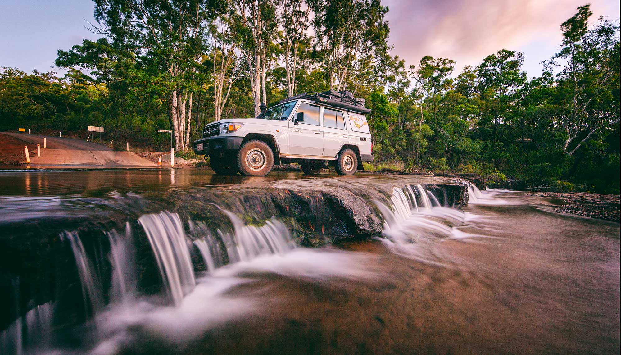
If there’s one road trip to be crowned “epic”, it’s the stretch between Cairns and the tip of the Cape York Peninsula. 4WD moguls will have the time of their lives, with creek crossings and corrugations to tackle along the way.
Cape York is as much about the drive as it is the destination and along the way you’ll experience Indigenous culture, stay at outback stations and see critters that you’ll find nowhere else in the world. So fit out your off-roader with a snorkel, spare tyres and fuel, and pack heaps of drinking water and set off on this adventure of a lifetime.
Please be respectful during your trip to The Tip. Find out more about how to be a conscious traveller in Cape York.
DAY ONE
Cairns to Cooktown
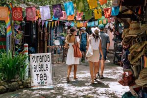
With so much off-roading down the track on the trip to the tip, let’s start off easy by taking the inland Mulligan Highway from Cairns to Cooktown. Travel “up the hill” from Smithfield, north of Cairns, to Kuranda and check out the Heritage and Original Rainforest Markets.
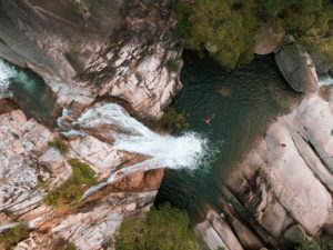
Kick-start your journey with a cuppa at Jaques Coffee or wake up with a refreshing splash at Emerald Creek Falls. If you’ve got time to spare, feel free to spend a few days up in Mareeba and the Atherton Tablelands while you’re in the area – there’s plenty to explore!
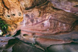
Head onto the Mulligan Highway towards Cooktown. Pull over at Quaid’s Dam between Mareeba and Mt Mulloy for a spot of bird watching. James Earl Lookout and Bob’s Lookout over sweeping views of the bushlands en-route. If you fancy extending your trip, detour to Laura for the Quinkan Rock Art Sites.or spend a few days on country with Traditional Owners at Jarramali Rock Art Tours.

As you drive toward Cooktown you will notice mountains made of large black boulders. This impressive place is Black Mountain National Park (Kalkajaka). Pull over at the lookout to marvel at this unique landscape, which is incredibly significant to its Traditional Owners, the Eastern Kuku Yalanji People. Signs at the lookout detail the mountains natural geology, plant and animal life and history.
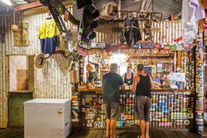
Head five minutes off the highway and celebrate your arrival into Cooktown with a cold one and hearty meal at the Lion’s Den Hotel, a stop so legendary that the walls are covered with signatures from road trippers from all over the world. The nearby Trevathan Falls are a lovely little detour and are one of the only croc-free waterfalls around Cooktown to cool off in.
Stay: The Sovereign Resort is a little bit of luxury in the heart of Cooktown and has an onsite Café Bar and balcony restaurant for a bite to eat.
Optional Detour – 4WD tracks and cattle stations
Spice up your drive along the Mulligan Highway with a stop off at Palmerville Station, a 331,000-acre cattle station accessed via White’s Creek Road, roughly 20kms before the highway crosses the Palmer River. A few days can be easily filled with family- friendly activities including cultural tours, historic gold mining ghost towns, fishing, and gold fossicking on the famous ‘River of Gold’. Return to the highway the same way or test your 4×4 skills on the Old Coach Road to Laura.
If you fancy starting off your trip on the more rugged side instead, skip in the inland highway and head north along the coast. Choose your route – Bloomfield Track or CREB Track.
Those looking to up the ante and push their rig to the max can veer towards the CREB Track, which can be found deep upstream the Daintree River on the Upper Daintree Road. Cross the Daintree River at the sign and tackle 71km of off-road challenges.
If you want something scenic that’s just a little challenging, the Bloomfield Track is calling you. Wind your way through the Daintree and Cape Tribulation before off-roading your way through Wujal Wujal.
DAY TWO
Cooktown
It doesn’t get more true-blue Aussie than Cooktown, a charming seaside town with a population of just 2,631. Start your day by the Cooktown Marina and sit down at Riverside Cafe for a French pastry and watch the locals cast lines.
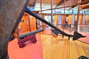
You’ll want at least a day dedicated to Cooktown. This town is teeming with history; James Cook ran the HMB Endeavour onto the Great Barrier Reef, forcing him and his crew to Spend 48 days in Cooktown. Some of the relics from the HMB Endeavour can be seen at the James Cook Museum, which is chock-a-block with local history. Next on the Museum crawl is Cooktown History Centre, which has a huge collection of historical maps, photos and documents.

Take your history lesson to the great outdoors at the Cooktown Botanic Gardens, which were established in 1878. The gardens house species collected by Joseph Banks and Daniel Solander in 1770, as well as many local rainforest species. Munch on some goodies at the cafe and wander to Finch Bay and Cherry Bay on walking tracks from the garden.
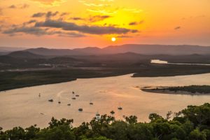
Finish off your day with a stellar sunset from Grassy Hill, which offers stunning views over the Endeavour River and Cooktown.
DAY THREE
Cooktown to Rinyirru (Lakefield) National Park

Hit the highway and head north towards Hopevale, keeping your eyes peeled for signs to Rinyirru. Pull up for a pit stop at Endeavour Falls Tourist Park and have a gander at Endeavour Falls for a gold coin donation. But don’t get your togs out yet – a swim here is off the cards due to salties.
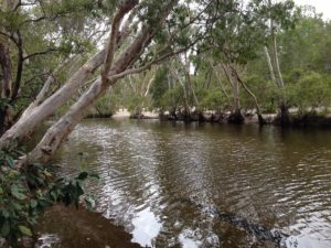
If you want to wash off the dust, Isabella Falls is also on the way to Rinyirru (Lakefield) National Park and offers croc-free swimming.

Rinyirru (Lakefield) National Park is the largest in Cape York and has a variety of ecosystems and wildlife spotting opportunities. Fishing is allowed at all of the camping spots and you can try your luck at casting for barramundi.
Stay: The national park has a few camping spots, including camping at Hann Crossing and Kalpowar Crossing, but make sure you book in advance.
Optional Detour – Elim Beach and the Coloured Sands
Head west through the Indigenous township of Hope Vale to Elim Beach, home to the stunning coloured sands. At low tide you can drive along the white sandy beach stopping to check out the vibrantly-coloured sand cliffs. Pick up a day pass at Eddie’s Campground or stay overnight at their beachfront camping grounds.
DAY FOUR
Rinyirru (Lakefield) National Park to Coen
Today’s drive will take you 141km north to Coen, a small town at the centre of the Cape York region. On your journey down the red dirt roads, keep your eyes peeled for huge termite nests and birds. If you’re feeling as dusty as Slim, jump into the shallow waters of the Coen River, which croc-free.
Stay: Get a good night’s sleep at the Homestead Guesthouse, located alongside Lankelly Creek.
DAY FIVE
Coen to Bramwell Station
The 216km stretch between Coen and Bramwell Station is all red dirt and dust. Fuel up yourself with a feed at Archer River Roadhouse then cross the Wenlock River to find the Moreton Telegraph Station. 734 species of critters call this place home, so it’s a great place to get out the binoculars and do a bit of wildlife spotting. Locals you may meet include Palm Cockatoos and the elusive Antilopine Wallabies.
Continue 30 minutes north and pull up at Bramwell Station, the most northerly cattle station in Australia. Stop over at the tourist park and boogie the night away to live music acts.
Optional Detour – Weipa or Portland Roads
Portlands Roads is an equally stellar detour and has a rich history. Head into the Iron Range, the largest area of lowland tropical rainforest in Australia and search for rare and endemic plants and animals. Nearby Chili Beach is made of white quartz sand and has views to Restoration Island.
DAY 6
Bramwell Station to Elliot Falls

Hold onto your dacks for the most challenging part of the Old Telegraph Track – Gunshot Creek Crossing! This almost vertical drop is so iconic that the trees on the northern bank of the creeks are filled with memorabilia from those who have braved it – and lived to tell the tale.
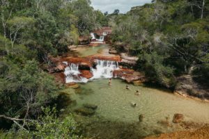
If you’re still a bit sweaty from Gunshot-creek-induced adrenaline, a refreshing dip in Fruit Bat Falls is just 33kms away. Jardine River National Park is also home to the stunning Elliot Falls and Twin Falls, which right next to each other. With so many incredible waterfalls, it’s well worth spending a whole day in this area.
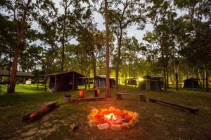
Stay: Elliot Falls Campground has drop toilets, picnic tables and a firepit. Plus it’s only a short walk to the falls, so repeat visits are a must.
DAY SEVEN
Elliot Falls to The Tip

Trek 61km north to the Jardine River and cross it on the vehicular ferry, costs vary per vehicle and tickets can be purchased here. A further 48km north will see you in Seisia, which is actually pronounced “say see ya”. Locals will tell you that its home to Australia’s best fishing wharf, so cast a line and see if you can land yourself a big fish.
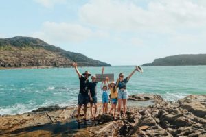
Continue to Punsand Bay, just 5km west of The Tip. The legendary sign itself is a 20min walk from the car park and is best accessed at low tide. Let’s be real – did you even go to The Tip if you didn’t get a photo at the “You are standing at the most northern point of the Australian Continent sign”?
Stay: Punsand Bay has a beautiful beach–front campground complete with a restaurant and bar so that you can enjoy a cold one in Australia’s most northern point.
Optional Detour – Torres Strait Islands
Extend your trip by heading out to the Torres Strait Islands. Peddell’s run ferries from Seisa to Thursday Island at least once a day. Or join an Indigenous guide for a return tour from Seisa to Thursday Island including highlights such as Green Hill Fort Lookout, Japanese Pearl Divers Memorial and more.
Learn More